
A Close Encounter with Super Typhoon Babs (Loleng)
Karl Hoarau's Personal Experience and Analysis
Here is my experience about typhoons in the Philippines in October 1998. When I arrived overthere I met Dr. Prisco Nilo and Mr. Lito Calimbas, forecaster's chief and technician at the satellite facilities service, respectively. They told me that I could phone them at any time to get information about typhoons location and intensity. I had an accommodation in Quezon City (Metro Manila) at 10 minutes by taxi from PAGASA.
I did not have the chance to chase Super Typhoon (STY) Zeb. In fact, when it began to move at 15 knots (kts) towards the northern Luzon by Tuesday 13th at 0000Z, the domestic flights and the bus were cancelled for the north.
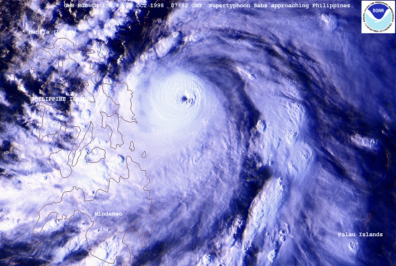
After STY Zeb, I did not want to lost a new occasion! And when Babs at typhoon
intensity (65 kts) began to move west-northwest on October 19, 1998 (see the best
track data) I decided to go to the south of the Philippines by plane. The plane took
off early (06h10 local time,2210Z) by Tuesday 20 October and the flight lasted 1h15
from Manila to Tacloban City in Leyte. Ty Babs was at 450 km east-south-east of Samar.
I went over Mac Arthur Bridge between Leyte and Samar and I arrived at Catbalogan in
western Samar after 2h of jeepney. It was 1030 am (0230Z), I phoned M. Lito Calimbas
(Pagasa) and he confirmed me that Babs was continuing on a west-north-westerly track.
The typhoon was undergoing an explosive deepening phase with an estimation of 75 kts
at 191800Z and 115 kts at 200000Z (JTWC).
 As it was not possible to go to the South of Luzon by boat, it was time to have a new
strategy because it was becoming evident that Babs would not made landfall on Samar.
Fortunately, there was still a plane for Manila from Tacloban at 0500 pm. I arrived
in Manila Domestic Airport at 0630 pm. I had a bus for the south of Luzon at 0730 pm.
It let me the time to phone M. Lito Calimbas once again. It was the last time I got
a position of Babs until my arrival at Legaspi (400km from Manila) by Wednesday morning
21 October at 0800 am. In fact, during the night I tried to find a telephone at each
bus stop from Daet (14.1°N and 123°E) to call PAGASA to have a new Babs location and
to know exactly in which city I had to get off, but I did not find it. So, I was
obliged to go to the bus terminal of Legaspi. I found an internet office and I knew that
Babs was a Super Typhoon of 135 kts since 201200Z. Outside, there were rainshowers.
At this moment my aim was how to be near the eye of Babs at Landfall. It was too late
to go to Catanduanes Island (13.6°N and 124.2°E) because the typhoon was only at 200 km
from Legaspi.
As it was not possible to go to the South of Luzon by boat, it was time to have a new
strategy because it was becoming evident that Babs would not made landfall on Samar.
Fortunately, there was still a plane for Manila from Tacloban at 0500 pm. I arrived
in Manila Domestic Airport at 0630 pm. I had a bus for the south of Luzon at 0730 pm.
It let me the time to phone M. Lito Calimbas once again. It was the last time I got
a position of Babs until my arrival at Legaspi (400km from Manila) by Wednesday morning
21 October at 0800 am. In fact, during the night I tried to find a telephone at each
bus stop from Daet (14.1°N and 123°E) to call PAGASA to have a new Babs location and
to know exactly in which city I had to get off, but I did not find it. So, I was
obliged to go to the bus terminal of Legaspi. I found an internet office and I knew that
Babs was a Super Typhoon of 135 kts since 201200Z. Outside, there were rainshowers.
At this moment my aim was how to be near the eye of Babs at Landfall. It was too late
to go to Catanduanes Island (13.6°N and 124.2°E) because the typhoon was only at 200 km
from Legaspi.
I was dead tired, I did not sleep at all in the bus and I was hungry too, I had just eaten
an ice cream before leaving Manila for Legaspi. I took the time to appreciate a good meal
but I have never thought to give up the chase. Babs was moving towards Catanduanes and
then Camarines Sur. I left Legaspi by 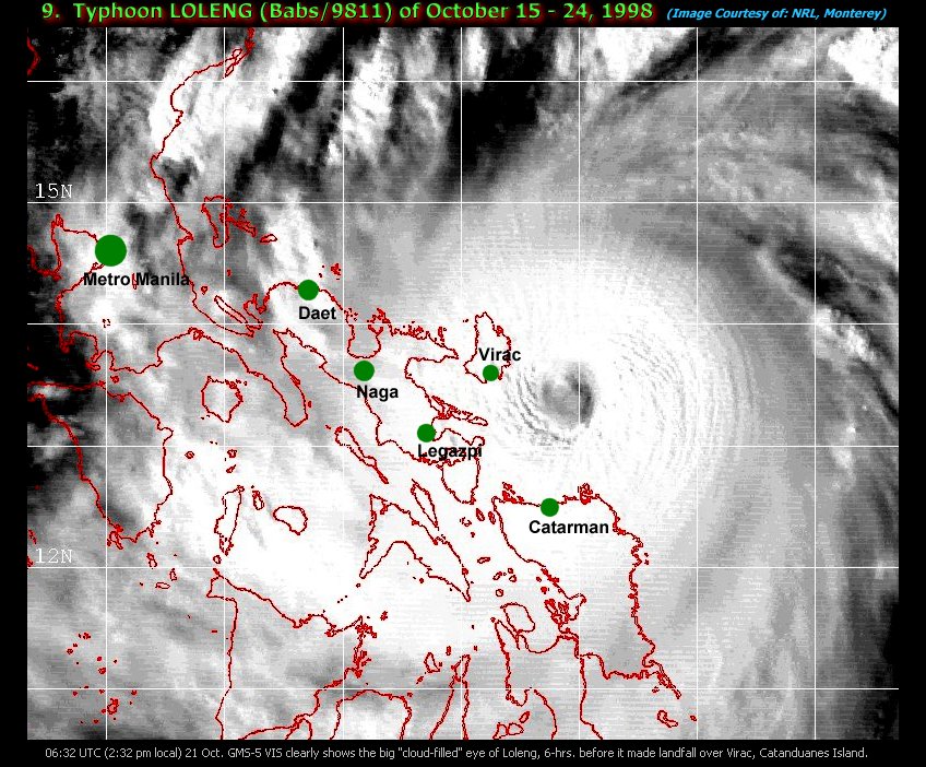 bus at 1100 am to go back to Pili, south of Naga,
and I had to take one more bus toward Camarines Sur, north-east of Naga. I arrived at
Lagonoy via Tigaon at 0230 pm. I wanted to go to Caramoan, 35 km east-north-east of
Lagonoy but it was too late. Babs was located 150 km east-south-east of Lagonoy moving
west-north-west at 6-8 kts. Visual GMS imagery at 0600Z (joined) indicated that Camarines
Sur was just entering into the CDO of Babs. There was 5 cm of water on the road and it
was wise to stay there. Anyway there was neither bus nor jeepney for Caramoan. I found
an Hotel at Lagonoy which seemed strong enough to withstand hurricane winds. I was very
happy to have a good shower and to take a nap. But I could not sleep, I was thinking
that if I had had no time to go to Caramoan it was because I had not found a telephone
during the last night to know Babs position. If I had, I should have probably got off
at Naga and I should have had time to go to Caramoan by this Wednesday morning 21 October.
bus at 1100 am to go back to Pili, south of Naga,
and I had to take one more bus toward Camarines Sur, north-east of Naga. I arrived at
Lagonoy via Tigaon at 0230 pm. I wanted to go to Caramoan, 35 km east-north-east of
Lagonoy but it was too late. Babs was located 150 km east-south-east of Lagonoy moving
west-north-west at 6-8 kts. Visual GMS imagery at 0600Z (joined) indicated that Camarines
Sur was just entering into the CDO of Babs. There was 5 cm of water on the road and it
was wise to stay there. Anyway there was neither bus nor jeepney for Caramoan. I found
an Hotel at Lagonoy which seemed strong enough to withstand hurricane winds. I was very
happy to have a good shower and to take a nap. But I could not sleep, I was thinking
that if I had had no time to go to Caramoan it was because I had not found a telephone
during the last night to know Babs position. If I had, I should have probably got off
at Naga and I should have had time to go to Caramoan by this Wednesday morning 21 October.
At 0400 pm, I adjusted my barometer graduated each 2 hPa: 1070 hPa would stand for 998 hPa.
At this time, Babs was located 135 km east-south-east of Lagonoy. Later, when I got
observations with PAGASA, I found that Virac station (Catanduanes) recorded a pressure of
998.1 hPa at 125 km of Babs center. The pressure was diminishing by 1 hPa/hour. So, the
pressures I recorded at Lagonoy were good within 2 hPa.
The winds increased really from 1000 pm (1400Z) and the pressure began to decrease with
an accelerated rate: 992.5 hPa at 1300Z and 988.0 at 1400Z. Babs was located 55-60 km
east of 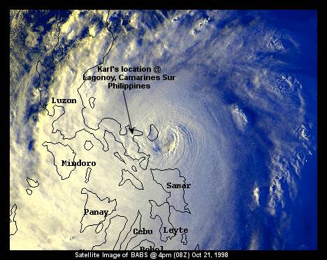 Lagonoy. It is quite impossible to estimate the winds speed the night when you
have no visual mark. Of course, the hotel had a generating set and I could have a view
a few meters outside thanks to a balcony at the opposite of the winds before Babs closest
point of approach. So, my marks were the noise made by the winds and a tree near the hotel.
The last cyclone I saw was TC Colina in Reunion Island (January 1993). I was a few
kilometers of Saint-Denis Airport station which recorded a MSW of 70 kts with 103 kts
gusts. And I remembered very well the noise of the winds (it was in the middle of the
afternoon). I can tell you that the noise was stronger in TY Babs. I heard very well the
boughs broken. According to PAGASA Radar at Baler (15.7°N and 121.6°E), TY Babs eye was
centered on 21 October at 1800Z around 13.9°N and 123.6°E, 20 km north-north-east of
Lagonoy (13.7°N and 123.5°E). The JTWC best track data (joined) gave a similar location.
The Radar revealed too that Babs had a circular eye of 30 km in diameter but it was open
in the north-west. That means I was in the southern eyewall from 1700Z to 2000Z. My
barometer indicated a minimum pressure of 952.5 hPa at 1820Z. As I got hourly Radar
locations of Babs eye I can give you an idea of the pressure gradient: for the first
10 km in the eyewall I found a pressure decrease of 16 hPa (968.5-952.5 hPa), for 20 km
a decrease of 25 hPa (977.5-952.5 hPa) and for 30 km a decrease of 32 hPa (984.5-952.5hPa).
If I consider that I was at 5 km of the eye edge, an extrapolation of the gradient for
these 5 km gives me an additional decrease of 8 hPa and around 2 hPa more for the eye. So,
around 1800Z Babs was a typhoon with a central pressure estimated at 940-945 hPa (Ci 5.5).
Lagonoy. It is quite impossible to estimate the winds speed the night when you
have no visual mark. Of course, the hotel had a generating set and I could have a view
a few meters outside thanks to a balcony at the opposite of the winds before Babs closest
point of approach. So, my marks were the noise made by the winds and a tree near the hotel.
The last cyclone I saw was TC Colina in Reunion Island (January 1993). I was a few
kilometers of Saint-Denis Airport station which recorded a MSW of 70 kts with 103 kts
gusts. And I remembered very well the noise of the winds (it was in the middle of the
afternoon). I can tell you that the noise was stronger in TY Babs. I heard very well the
boughs broken. According to PAGASA Radar at Baler (15.7°N and 121.6°E), TY Babs eye was
centered on 21 October at 1800Z around 13.9°N and 123.6°E, 20 km north-north-east of
Lagonoy (13.7°N and 123.5°E). The JTWC best track data (joined) gave a similar location.
The Radar revealed too that Babs had a circular eye of 30 km in diameter but it was open
in the north-west. That means I was in the southern eyewall from 1700Z to 2000Z. My
barometer indicated a minimum pressure of 952.5 hPa at 1820Z. As I got hourly Radar
locations of Babs eye I can give you an idea of the pressure gradient: for the first
10 km in the eyewall I found a pressure decrease of 16 hPa (968.5-952.5 hPa), for 20 km
a decrease of 25 hPa (977.5-952.5 hPa) and for 30 km a decrease of 32 hPa (984.5-952.5hPa).
If I consider that I was at 5 km of the eye edge, an extrapolation of the gradient for
these 5 km gives me an additional decrease of 8 hPa and around 2 hPa more for the eye. So,
around 1800Z Babs was a typhoon with a central pressure estimated at 940-945 hPa (Ci 5.5).
Before the passage of the eye, the winds was stronger around 1700Z (obviously I did not
sleep at all during the night, I was watching my barometer, trying to see outside and
listening to the noise). I suspect a valley located 300 m NNE of Lagonoy and oriented NNE
for having accelerated the NNE winds of Babs. In fact, there are mountains, 10 km wide on
40 km lenght parallel to the coast, with peaks at 700-1000 m. Babs center passed just in
the narrow littoral plain between the Ocean and these mountains according to the Radar
data. But even after 1700-1730Z the winds were strong and there was no calm. And then the
winds came from west and I was surprised that they were so strong at 2000Z. Lagonoy is at
the end of a corridor oriented west-east between the Mont Isarog (1976 m) located SW and
the mountains I was speaking about. In this situation, the winds were probably accelerated
at Lagonoy (50 m in altitude). The winds exploded two glass-windows without shutter in the
dining-room of the hotel. From 2200Z the winds began to decrease in a progressive manner:
at sunrise around 2300Z (0700 am) I could estimate the gusts at 150 km/h (eye at 50 km) and
I could go outside at 0330Z (1130 am) when the gusts had lessened to 100 km/h (eye at 100 km).
The damages have been very important. Many trees were down. The damage were lightly greater
than those produced by TC Firinga in Reunion Island in January 29, 1989. The 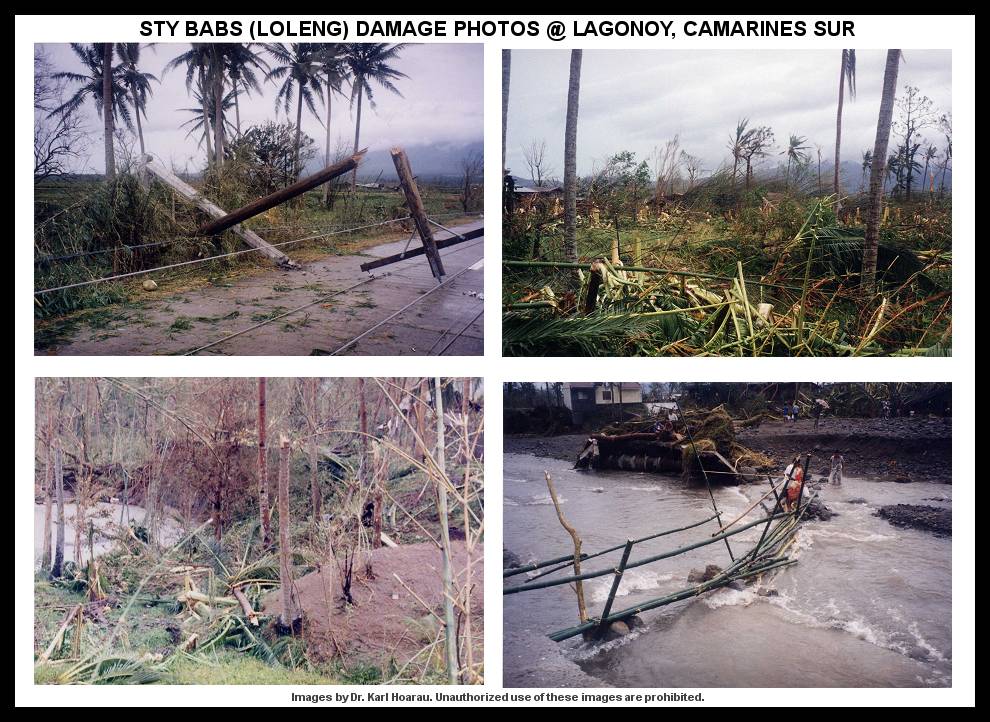 gusts had
reached 216 km/h. I did not live TC Firinga but I arrived in Reunion 4 days later. And I
remembered that in the strongest winds area some coconut-trees had been cut at the top.
At Lagonoy, I saw coconut-trees of similar size (height and diameter) broken lower than the
top. So, at Lagonoy the maximum gusts were around 220-230 km/h. Do not forget that these
winds have been accelerated by the topography. Of course, at Lagonoy I was not in the
more intense part of the Babs eyewall which was on the north side for a west-north-westerly
track. But Babs was moving at 8 kts near Lagonoy that means there was not a big difference
in the winds speed between the north and the south eyewall. If we consider Babs as a
typhoon with a Current Intensity of 5.5 by 211800Z, the maximum gusts were probably 125 kts
in the northern eyewall and around 105 kts in the southern eyewall. This would give an
increase of 15-20% due to the topography for the winds which have blown at Lagonoy. I left Lagonoy by Friday 23 October in the morning. I was obliged to walk a few kilometers
because the telephone-post were down the road and in some place the rivers had broken the
road. Then I caught a tricyle for Goa then a bus for Naga. I left Naga by the first plane
for Manila on sunday morning 25 October. It was a busy and tiring week but I'll never
forget it. My next target is "to catch" at least a T6 Tropical Cyclone if it is possible
during the day in Reunion Island or why not still in the Philippines to meet Michael?
gusts had
reached 216 km/h. I did not live TC Firinga but I arrived in Reunion 4 days later. And I
remembered that in the strongest winds area some coconut-trees had been cut at the top.
At Lagonoy, I saw coconut-trees of similar size (height and diameter) broken lower than the
top. So, at Lagonoy the maximum gusts were around 220-230 km/h. Do not forget that these
winds have been accelerated by the topography. Of course, at Lagonoy I was not in the
more intense part of the Babs eyewall which was on the north side for a west-north-westerly
track. But Babs was moving at 8 kts near Lagonoy that means there was not a big difference
in the winds speed between the north and the south eyewall. If we consider Babs as a
typhoon with a Current Intensity of 5.5 by 211800Z, the maximum gusts were probably 125 kts
in the northern eyewall and around 105 kts in the southern eyewall. This would give an
increase of 15-20% due to the topography for the winds which have blown at Lagonoy. I left Lagonoy by Friday 23 October in the morning. I was obliged to walk a few kilometers
because the telephone-post were down the road and in some place the rivers had broken the
road. Then I caught a tricyle for Goa then a bus for Naga. I left Naga by the first plane
for Manila on sunday morning 25 October. It was a busy and tiring week but I'll never
forget it. My next target is "to catch" at least a T6 Tropical Cyclone if it is possible
during the day in Reunion Island or why not still in the Philippines to meet Michael?
ADDITIONAL INFORMATION
I would like to give you additional information from data I got with PAGASA. Virac (13.6°N
and 124.2°E), the main city of Catanduanes Island, recorded pressures of 927.9 hPa by
211200Z and 928.9 hPa at 1300Z, respectively. Of course, the station was in the eye of
Babs. At 1300Z the winds were 8 kts  but there were moderate rains. The DMSP F14 imagery at 1231Z (joined) shows a 25-nm diameter clouds filled eye (MG gray shade with a DG point)
surrounding by very cold tops (-70°C to -75°C). This give you a T6 (115 kts) typhoon.
At this time the JTWC had overestimated the MSW with 130 kts in the best track data (joined).
Virac recorded a gust of 136 kts by northerly winds (coming from inner Island) at 1130Z
and a peak gust of 140 kts by southerly winds (coming from the ocean) at 1445Z. These data
match very well with a T6 cyclone. Moreover, Daet (14.1°N and 123°E) recorded a SLP of
963.5 hPa and 12 kts winds by 220100Z. The Radar of Baler indicated that Babs center was
centered 8 km north-east of Daet which recorded a MSW of 78 kts and a peak gust of 97 kts by
north-north-easterly winds on October 21 at 2300Z. Babs was moving northwestward at 5-6 kts.
By 220000Z the MSW of 105 kts given by the JTWC was still too strong. The data I gave you
for Virac and Daet were in the observations note-books I read in Quezon City (PAGASA) on
December 1998; I left the Philippines in January 29, 1999.
but there were moderate rains. The DMSP F14 imagery at 1231Z (joined) shows a 25-nm diameter clouds filled eye (MG gray shade with a DG point)
surrounding by very cold tops (-70°C to -75°C). This give you a T6 (115 kts) typhoon.
At this time the JTWC had overestimated the MSW with 130 kts in the best track data (joined).
Virac recorded a gust of 136 kts by northerly winds (coming from inner Island) at 1130Z
and a peak gust of 140 kts by southerly winds (coming from the ocean) at 1445Z. These data
match very well with a T6 cyclone. Moreover, Daet (14.1°N and 123°E) recorded a SLP of
963.5 hPa and 12 kts winds by 220100Z. The Radar of Baler indicated that Babs center was
centered 8 km north-east of Daet which recorded a MSW of 78 kts and a peak gust of 97 kts by
north-north-easterly winds on October 21 at 2300Z. Babs was moving northwestward at 5-6 kts.
By 220000Z the MSW of 105 kts given by the JTWC was still too strong. The data I gave you
for Virac and Daet were in the observations note-books I read in Quezon City (PAGASA) on
December 1998; I left the Philippines in January 29, 1999.
ANALYSIS
How can we explain the overestimation of the winds made by the JTWC from 21 October at 1200Z
to 22 October at 0000Z. The intensity estimation of the satellite made by PGTW are good (see Babs satellite analysis). The problem comes from the lag of the Current Intensity
behind the T number and from the intensity variation at landfall.
Babs underwent a weakening of 1 T number in 6 h between 201800Z and 210000Z.
The PGTW analysis for 210600Z is too strong: when you work with digital data, a DG eye with
a White surrounding gray shade give you a DT of 6.2 rather than 6.5. I agree with the T
number of 6 given at 1200Z but not with the Current Intensity of 7.0 (130 kts). In fact,
Babs had begun to weaken just after 1800Z on 20 October, so a Current Intensity of 6.5
should have been more appropriate in theory. In the other hand, Babs made landfall on
Catanduanes Island at 1200Z. It is a small (30 km wide and 55 km lenght) but rough island
and Babs core circulation was already affected by Luzon. As for STY Zeb, the JTWC did not
take into account an additional weakening due to the landfall. Zeb case showed very well
that the weakening is faster at landfall than in the middle of the Ocean.
I think Michael would agree with me: you can chase typhoons in the Philippines from June
to December, but October and November typhoons are the strongest.
Northern Luzon is interesting to chase typhoons as long as they are very strong and they move rapidly through the mountains. In the narrow littoral plain east of the Sierra Madre, there are a few villages where you can wait for typhoons. But the road from Cagayan Valley are rough and it takes you a long time. The existent data in the Philippines about typhoons show that the best spot to chase typhoons is Southern Luzon: a SLP of 909.5 hPa has been recorded at Legazpi City (13.1°N and 123.7°E) on November 1987 in Super Typhoon Nina (Rosing). In the Northern Luzon, observed SLP has never been lower than 955 hPa at Tuguegarao and 945 hPa at Aparri (18.3°N and 121.6°E).
Other Topics by Dr. Hoarau:
:: Have there been any typhoons stronger than Super Typhoon Tip? (in PDF format)
Related Information: