|
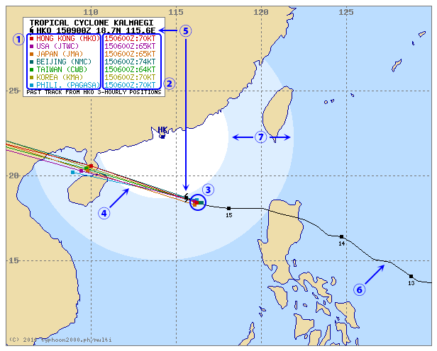
- Meteorological agencies
- HKO: Hong Kong Observatory (香港天文台)
- JTWC: Joint Typhoon Warning Center (美國聯合颱風警報中心)
- JMA: Japan Meteorological Agency (日本氣象廳)
- NMC: National Meteorological Center (中國中央氣象台)
- CWB: Central Weather Bureau (台灣中央氣象局)
- KMA: Korea Meteorological Administration (韓國氣象廳)
- PAGASA: Philippine Atmospheric, Geophysical and Astronomical Services Administration (菲律賓大氣地球物理和天文服務管理局)
- Forecast base times and initial intensities
- E.g. “150600Z” = 06:00 UTC on 15th day of month
- UTC = GMT = 8 hours behind HK time
- “150600Z” = 2:00 p.m. (HK time) on 15th day of month
- E.g. “70KT” = 70 knots
- 1 knot = 1.852 km/h ≈ 0.514 m/s
- “70KT” ≈ 130 km/h or 36 m/s
- Initial positions (here, at 150600Z)
- Here, the dots do not overlap with each other, meaning that the agencies were not in good agreement as to Kalmaegi’s initial position; this is because Kalmaegi was re-organizing itself after crossing Luzon and its eye was not well-defined
- Forecast tracks
- Each dot represents position 24 hours after preceding one
- For each agency, forecast track up to 120 hours ahead may be available
- Latest position (here, at 150900Z)
- Available when close-up tracking map (i.e. map bounded by 10-30°N, 105-130°E – the one shown here) is displayed
- Updated hourly by HKO when Tropical Cyclone Signal No. 1 or above is in force in HK, or every 3-12 hours otherwise
- Past track
- Based on HKO’s 3-/6-hourly data when close-up tracking map is displayed, or JTWC’s 6-hourly data otherwise
- Numbered dots represent daily positions at 00:00 UTC
- Distance from HK
- Inner circle: 400 km from HK
- Outer circle: 800 km from HK
|