
THE TWELVE WORST TYPHOONS OF THE PHILIPPINES
(1947-2009)
This summary is based on news, weather reports and storm logs, NDCC publications, historical archives and personal accounts.
Individual tracks are courtesy of Unisys.com. Satellite Images courtesy of Karl Hoarau, NPMOC/Joint Typhoon
Warning Center (taken from the 1970, 1984, 1991 and 1993 ATCRs), NOAA, & Digital-Typhoon.org.
Tropical Storm URING (Thelma)
November 2-7, 1991
95 kph
5,101 deaths (unofficial estimate up to 8,000 +)
PhP 1.045B damage
Core (Eye & Eyewall) Track: Maydolong, Eastern Samar; Tacloban City and Ormoc City, Leyte; Northern Cebu, Northern Negros Occidental specifically Escalante, Murcia, Bacolod City, Bago City and Pulupandan; Southern tip of Guimaras; just south of Cuyo Is.; Roxas in Northern Palawan.
URING was a weak tropical storm that moved quickly through Samar, Leyte, Cebu and Negros. But because of the heavy precipitation, rivers swelled and landslides came down in a deluge in the mid-morning of November 5 at the upper areas of Ormoc City in Leyte. The river bisecting the city burst its banks and overflowed, drowning the whole city in more than 10 feet of water laden with mud and debris. Thousands were caught flatfooted and perished. The storm then moved over Northern Cebu flooding more towns and cities.
When URING arrived at Northern Negros by early afternoon, it dumped heavy rain flooding Northern Negros, wiping out houses from their foundations along rivers in Bacolod City and Victorias while leaving others marooned in the fast rising waters of the rivers. A section of a historic bridge across Bago River was swept by raging torrents. Late that night URING unleashed landslides in the mountainous southern town of San Joaquin in Iloilo Province and as far as Calinog in Central Iloilo where large rivers destroyed bridges spanning across them, cutting off some towns from their neighbors for a few days. Almost lunchtime of November 6, the storm crossed Northern Palawan through Roxas. The storm further weakened as it exited to the South China Sea at early evening.
Ormoc City and Northern Negros Occidental were scenes of devastation as the floods receded. Almost a quarter of Ormoc's population drowned and their bloated bodies were littered everywhere in the city while other fatalities were numerously floating at Ormoc Bay and Camotes Sea being feasted by sharks and other fishes. Many journalists and eyewitnesses described Ormoc City as
a scene from the Holocaust where dead bodies were stacked upon each other like logs or garbage.
Even those watching from television footages could not help but gag, retch, get misty-eyed or even weep quietly for everything was " truly sickening with the stench of death everywhere.
Due to the overwhelming number of dead bodies everywhere, there was a shortage of coffins, so authorities opted to collect the dead through dump trucks and buried in mass graves. It was considered the deadliest natural disaster of the country.
 Fig. 1. Track of URING. |
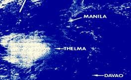 Fig. 2. Scanned Satellite Photo of URING |
Super Typhoon ROSING (Angela)
October 30-November 4, 1995
260 kph
936 deaths
PhP 10.829B damage
Core (Eye & Eyewall) Track: Northern tip of Catanduanes; Siruma and Quinabucasan Point, Northern coastal areas of Camarines Sur; Daet and the rest of the Northern coast of Camarines Norte; Mauban, Quezon; Santa Cruz and the southern shore towns of Laguna Lake, Laguna; southern portions of National Capital Region including Cavite City; Southern tip of Bataan specifically Mariveles incl. Corregidor Is.
ROSING was one of the strongest typhoons in the Philippines to hit land with gusts reaching up to 260 kph as it approached the Bicol Region at late evening of All Saint's Day (see figures 3 & 4).
This large-sized typhoon just came a day after Typhoon Pepang ravaged Leyte, Cebu, Negros and Panay. ROSING was quite slow-moving and erratic as it approached the country early morning of October 30 prompting authorities to alert a wide area of the Visayas up to Northern Luzon.
By the morning of November 2, ROSING's path changed sharply from northwest to a westward track and threatened to hit Catanduanes but its eye just skirted along the island's northern coast, that evening and moved to target Northern Camarines Norte. Despite the quick strike, Catanduanes was heavily devastated. Threatening Daet, it moved again slightly west and made landfall by dawn of November 3 at Siruma, Camarines Sur which lies at the mouth of San Miguel Bay. One resident of Caramoan, a nearby town, spoke on what she witnessed during the passage of its eye.
"It was eerie," she said. "the moon and some stars went out during the calm moment with continuous flashing of lightning somewhere along the area surrounding the eye."
Daet was directly hit after an hour by ROSING as she scoured more of Camarines Norte. Rosing's large eyewall, where the strongest winds and heaviest rainfall of a typhoon are located, was experienced to as far as Naga City as it passed 40 kilometers to the north. After flattening thousands of houses, trees, electric posts and power lines the howler then crossed Lamon Bay toppling down large coconut groves and more infrastructures and houses of Calauag, Quezon and spawned storm surges in the Quezon coastline as with the rest of the province. Landslides blocked roads in the mountainous regions of the province.
By mid-morning of that day, it started to wreak havoc in Laguna then later Metro Manila as far as Cavite and Bulacan destroying glass windows and panels of high-rise buildings, skyscrapers and other infrastructures. Metal and steel trusses of buildings, neon billboards and even large flagpoles were twisted, uprooted and destroyed. By noon, ROSING crossed Manila Bay devastating more at Southern Bataan and exited to the South China Sea by early morning of the next day. It was a full 60 hours of winds greater than 240 kph which was not even affected by prolonged land interaction.
Dead and bloated bodies of people, cattle and other animals were floating in Calauag Bay after the typhoon with others mangled and decomposing along the seacoast. Aerial surveys of Quezon Province and Bicol right after ROSING were described to be "a severe natural calamity to the maximum degree. Truly a wrath of nature's violent fury."
 Fig. 3. Track of Super Typhoon ROSING. |
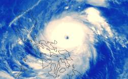 Fig. 4. Satellite Photo of ROSING Fig. 4. Satellite Photo of ROSING |
Typhoon FRANK (Fengshen) New Entry!
June 18-23, 2008
172 kph
938 deaths (unofficial estimate up to 1,501)
PhP 13.321B damage
Core (Eye & Eyewall) Track: Llorente, Eastern Samar; Zumarraga, Samar; Maripipi Is.; Esperanza, Masbate; Jintotolo Channel; shoreline of New Washington and Kalibo, Aklan; Sibuyan Sea off Tablas, Romblon; Romblon and Corcuera Islands, Romblon; Marinduque; Lucena City, Quezon; Sta. Cruz, Laguna and Laguna Lake; Taytay and Cainta, Rizal; Quezon City; most of Bulacan; San Fernando and Arayat, Pampanga; Central Tarlac Province; Cape Bolinao, Pangasinan.
As a tropical storm in June 19 at the Philippine Sea east of Surigao, FRANK slowly drifted towards the southern tip of Samar. As forecasted earlier it is expected to sideswipe Eastern Samar and miss the country. After 24 hours, it intensified into a typhoon and grew in size shifting west-northwest, making landfall at Llorente, Eastern Samar around 1:30 PM destroying coconut groves and homes. (see figures 5 & 6)
By 5 PM of June 20, FRANK maintained strength as it traversed Samar. Forecasters plotted again that FRANK will move north to Bicol and exit the country but FRANK defied the forecast hitting the smaller islands of Samar. Various weather agencies then updated various forecasts with FRANK northward to Camarines and Quezon Provinces and will exit the country, while others plotted it moving northwest thru Masbate and to Southern Tagalog. Marine vessels were then advised to seek shelter in the nearby islands of Northern Panay and Romblon. Around 8 PM, FRANK slowly jogged westward sweeping the southern tip of Masbate. It then entered Jintotolo Channel rampaging over fishing vessels fleeing the typhoon westward from the Visayan Sea. At 2 AM June 21, the typhoon started intensifying from 150 kph to 170 kph wind gusts and massive rainclouds of its southern eyewall started enveloping Bantayan Island, Northern Negros and Panay. That time an entire fishing fleet from Cadiz City, Negros Occidental was racing to seek shelter in Capiz and Northern Iloilo thinking the storm would move north. But FRANK still moved west catching them unaware and their boats were tossed and destroyed drowning more than a hundred of its crew.
By break of daylight of June 21, FRANK's 170 kph winds were churning Jintotolo Channel and the coastline of Capiz. The typhoon's westward track continued towards the coastline of Aklan. In the middle of the day, FRANK further intensified and enlarged with its southern half dumping record-breaking rainfall all-over Panay. FRANK brushed its eyewall at the coast of Kalibo destroying much of its coastal area and flooding the town with muddy water. Then simultaneously, large rivers of Panay (Aklan, Capiz, Antique and Iloilo) started breaching and tons of mud and debris-laden floodwaters scourged densely populated towns. Iloilo Province was hard-hit with its capital submerged in 15-foot raging floodwaters killing hundreds. Then at its peak intensity FRANK, suddenly turned about at the Kalibo coastline moving north to Sibuyan Sea. At that very moment Cebu-bound inter-island ferry, M/V Princess Of The Stars laden with 800 persons was also entering Sibuyan Sea, heeding to earlier warnings to seek shelter in Romblon. But the ferry's crew had no idea that they are sailing in collision against FRANK's eyewall. The ferry capsized over the shallow waters of Sibuyan Island drowning and trapping hundreds (click here to view Satellite Map). Storm surges, floods, and landslides continued killing and destroying Panay's populated areas including the famous Boracay Island. FRANK then raced rapidly northward raking Marinduque and Quezon Province. Southern Tagalog was caught unprepared as the typhoon slammed with strong winds and rain. Then the storm trailed at the western slope of Sierra Madre around midnight until dawn Of June 22, sweeping over Quezon City, flooding the metro and suburbs. Weakened by the landfall to 150 kph, FRANK continued ravaging Bulacan, Pampanga, Tarlac spawning floods before exiting via Cape Bolinao in Pangasinan. While at the South China Sea, FRANK moved again northeast passing over northern Batanes. FRANK was very destructive in many ways including forecasting blunders of monitoring agencies. Hundreds of marine vessels around the Visayas were destroyed. Iloilo and Aklan province were the most devastated provinces with floods never seen before in history of the region. Rescue and relief efforts were delayed due to damaged roads and bridges, and the focus of rescuers on trapped people in the capsized ferry. The unpredictable behavior of FRANK traversed seven islands, directly affecting 16 provinces and spawned floods as far as Central and Western Mindanao. Typhoon NITANG (Ike) Core (Eye & Eyewall) Track: Siargao and Nonoc Is., Surigao del Norte incl. Surigao City; southern tip of Southern Leyte and Panaon Island; Northern Bohol; Carcar, Aloguinsan and Barili in Southern Cebu; between Guihulngan and Vallehermoso in Northern Negros Oriental; Central Negros Occidental specifically La Castellana and La Carlota City; Guimaras; Southwestern Iloilo specifically Tigbauan and Igbaras; San Jose de Buenavista, Antique; Northern Cuyo Islands; Coron Is., Palawan. NITANG made landfall at the island of Nonoc and coastline of Surigao del Norte at about 2 AM of September 2 (see figures 7 & 8) and ravaged Surigao City with its strongest winds for the rest of dawn leaving the city totally devastated. With high winds and torrential rain, Lake Mainit bordering Surigao del Norte with Agusan del Norte spilled its contents washing away more than a thousand homes along its shores killing hundreds. After crossing the southern tip of Leyte later that morning, the typhoon slightly weakened but dumped torriental rains in Camiguin Island and Bohol creating mudslides and flashfloods. NITANG then crossed Cebu by lunch time destroying thousands of homes leaving the province with a single radio station broadcasting. It then approached Negros early afternoon. With the fury when it hit Surigao earlier it sent more torrential rains. It bludgeoned the heart of Negros Island and the cities of Bacolod and Dumaguete. Ilog River, the largest in Negros Island found at Southern Negros Occ. burst its banks and sent a deluge of mud, water, debris and thousands of logs to the municipalities of Kabankalan and Ilog killing hundreds. Survivors clambered to rooftops and attics of two storey houses while others clung on tall trees for almost two days without food and water. NITANG weakened as it crossed southwestern Iloilo, through its mountains and to Antique's capital by early evening spawning floods and landslides. Still with typhoon strength, it ravaged Cuyo Islands and Coron, Palawan and exited to the South China Sea by midday of September 4. Super Typhoon REMING (Durian) Core (Eye & Eyewall) Track: Southmost tip of Virac Point, Catanduanes; Tabaco and Tiwi in Albay; Mt. Iriga, Iriga City, Baao, Bula and Pasacao in Camarines Sur; (Bondoc Peninsula) Pugos Pt., San Narciso and Mulanay, Quezon; Sta. Cruz and Boac, Marinduque; Calapan City, Baco and San Teodoro, Oriental Mindoro; Binarera Point between Paluan and Mamburao, Occidental Mindoro. This usual looking typhoon forming in the Pacific slowly during the 28th of November would become the country's worst typhoon since records have been written. (see figures 9 & 10) Two days since its birth in the Philippine Sea near the south of the Marianas REMING intensified into a typhoon of minimal strength. But in less than 24 hours it strengthened to an even large, solid rotating mass of pure fury.
By the early hours of November 29 this angry typhoon reached deadly gusts of 240 - 260 kph as it roared towards Northern Samar and Catanduanes. REMING, fueled by the warm Philippine Sea along the Bicol Region, increased to winds of unimaginable strength and spraying heavy rain as far as Northern Visayas up to the rest of Luzon. In just a few hours the powerful howler neared Catanduanes inflicting damage on coastal towns of Northern Samar and Sorsogon due to raging sea waves. Not long, by noontime REMING's gusts went past 280 kph and ticking towards 300 kph! REMING churned Lagonoy Gulf and headed for Camarines Sur but along its wake ferocious winds left almost nothing of Rapu-Rapu and Batan islands, stripped-off the forests of Catanduanes, destroying 80% of all its houses and buildings, and ramming ships and tankers aground. The anemometer at PAGASA's weather station at Virac conked out after registering a 320 kph gust. It was the signature of the country's most powerful typhoon in history. Legazpi City and the rest of Albay which was under its intense Southern Eyewall, bore the brunt of the typhoon as large buildings lost their roofs while concrete and steel structures crumpled and bowed down everywhere. REMING came ashore the town of Tiwi in Albay. Everywhere, houses were literally blown off to pieces and then, the abrupt calm of the passing eye. But above Mayon Volcano, torrential rains continued and the saturated volcanic debris finally gave way. With the howling winds full of deadly debris, the raging lahars that thundered down the volcano's slopes gave people no time, or choice to escape. Those who clambered above their roofs as mudflows raged on were killed or critically injured by the flying debris. It left most of Albay and southern Catanduanes helpless and dying. Devastation spread across Camarines Sur as REMING quickly moved west. Naga City which was under the Northern Eyewall, was battered heavily by the winds with some low-lying areas under partial floodwaters. Large trucks were flipped and buildings never escaped damage. Crossing Ragay Gulf, the howler destroyed poverty-stricken fishing towns of Southern Quezon and then on to flatten more houses and vegetation at Marinduque. The weakening typhoon ravaged southern shores of Batangas and destroyed more of northern Mindoro after hitting Calapan City. REMING then exited towards the South China Sea by dawn of December 1. With power and communication lines down, it took a day for Filipinos to see the full-picture of REMING's aftermath. Aerial surveys of Camarines Sur, Albay and Catanduanes showed complete devastation. Schools, government structures, hospitals, banks and many important buildings were destroyed. At the foot of Mayon Volcano, whole families, villages and barangays were buried in volcanic debris giving up most of the fatalities. Officials estimated 1,200 dead and missing reminding them of Mayon's famous 1814 eruption. The missing surpassed the official death toll and was presumed to be dead beneath tons of mud and rocks. Super Typhoon RUPING (Mike) Core (Eye & Eyewall) Track: Dinagat Island; Southern Leyte; Mactan Island, Cebu City and the rest of Central Cebu Island; San Carlos City, D.S. Benedicto, Murcia and Bacolod City in Negros Occidental; Northern Guimaras; Iloilo City and the Southwestern Iloilo Prov.; Hamtic and San Jose de Buenavista, Antique; Northern part of Cuyo Islands; Linapacan Strait, Northern Palawan. RUPING was the country's most devastating typhoons inflicting more damage than any other typhoon had done since 1947 (see figures 11 & 12). It was a large and powerful howler as it approached Surigao del Norte in the early afternoon of November 12. Heavy damage was already inflicted in Surigao before RUPING made landfall at Dinagat Island at midnight and headed for Southern Leyte by early morning of November 13 devastating Maasin and its neighbors. By late in the afternoon of that day RUPING went off at the sea and maintained its strength as it moved towards Mactan-Cebu area. The howler rampaged Mactan Island destroying and almost leveling all houses in the small municipality-island of Cordova nearby, smashing and sinking ships in the harbor, and then to the heart of Cebu City by the early evening until early dawn of the next day leaving the metropolitan helpless without electricity and drinking water amidst the terrible debris everywhere. Thousands of houses in the rural areas of the province were leveled and destroyed by its ferocious winds. The passage of the eye in Cebu during dusk until late evening of Nov. 12 was quite unnoticed for everybody was still recuperating form the passage of the eyewall of the leading side. It was silent for an hour so others thought that the typhoon was over. Cebuanos started to pick up the pieces and debris while some tucked them to sleep, only to be ravaged again by the other side of the eyewall around late evening until dawn. The typhoon maintained its strength as it greeted the early morning of Bacolod City and the rest of Negros with a tempest never seen since 1951 flattening sugarcane fields and snapping electric posts to splinters. The eye was calm and sunny with birds flying around when it came over, but not far away, a wall of dark clouds could be seen coupled by continuous howling of the winds. By midday, it struck Iloilo City, bearing more devastation to houses and buildings, and then towards Antique shortly after lunch spawning raging floods in the province's major rivers. By the early evening of November 13, it was at the vicinity of Linapacan Strait, Palawan flattening more houses before exiting to South China Sea. Despite its intensity, deaths were lesser than expected due to preparations beforehand but it was too catastrophic that the whole Mindanao, Visayas, Central Luzon, NCR, Bicol and Southern Tagalog Regions sustained heavy damage and were considered calamity areas. RUPING affected 1,010,004 families or total affected persons of 5,498,290. The large eye of typhoon RUPING was also fully appreciated by more than a million people of the affected population after passing directly over large and densely populated cities of Lapu-Lapu, Mandaue, Cebu, Bacolod and Iloilo.

Fig. 5. Track of Typhoon FRANK.
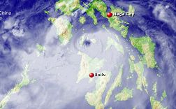
Fig. 6. Satellite Photo of FRANK.
August 31-September 4, 1984
220 kph
1,363 deaths (unofficial est. 1,492-3,000 +)
PhP 4.1B damage

Fig. 7. Track of Typhoon NITANG.

Fig. 8. Scanned Satellite Photo of NITANG.
November 26-December 1, 2006
320 kph
734 deaths (unofficial estimate up to 1,200)
PhP 5.086B damage

Fig. 9. Track of Super Typhoon REMING.
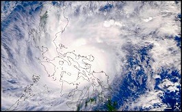
Fig. 10. Satellite Photo of REMING.
November 10-14, 1990
220 kph
748 deaths
PhP 10.846B damage
 Fig. 11. Track of RUPING
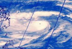
Fig. 12. Satellite Photo of RUPING
Super Typhoon SISANG (Nina)
November 23-27, 1987
240 kph
979 deaths
PhP 1.119B damage
Core (Eye & Eyewall) Track: Northern tip of Sorsogon Province; Albay specifically Legazpi City; Southern Camarines Sur particularly Iriga City and the municipalities of Nabua and Bato; Burias Is., southern tip of Bondoc Peninsula of Quezon Prov.; Marinduque, Verde Island, Puerto Galera and coastline of Oriental Mindoro and Batangas Province, Lubang Island.
SISANG was a powerful howler that made landfall at the Northern tip of Sorsogon by the evening of November 25 and spawned a large storm surge that ravaged Legazpi City. The large eye passed directly over Legazpi City and unleashed horrible damage to Albay with mudslides that thundered down Mayon Volcano and tremendous surges that swept the seacoast clean of houses, ports and sea vessels (see figures 13 & 14).
After hitting Legazpi, SISANG made its way to lash directly with its eye over Iriga, the small southern city of Camarines Sur before exiting Burias Strait. Naga City also sustained heavy damage as the northern part of the eyewall passed by. Groves of coconut trees and steel power lines were snapped in two or twisted in unexplainable shapes. Many died from flying debris caused by the tremendous winds while others drowned from flashfloods and storm surges.
It then crossed Burias Island at dawn of November 26 and then wrecked Marinduque later that morning and then, creating havoc to Calapan and Puerto Galera in Oriental Mindoro destroying more houses and buildings including historic churches and basilicas in the densely populated province of Batangas. It then exited to the South China Sea by the evening. As SISANG further weakened, it recurved back to the country threatening Ilocos Region but later dissipated.
 Fig. 13. Track of SISANG . |
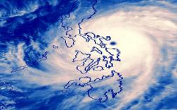 Fig. 14. Satellite Photo of SISANG |
Super Typhoon SENING (Joan)
October 11-15, 1970
275 kph
768 deaths
PhP 1.89B damage
Core (Eye & Eyewall) Track: Virac Point, Catanduanes; Sagñay and Naga City in Camarines Sur; inner portion of Ragay Gulf, Calauag, Lopez Bay coastline, Atimonan and Lucban in Quezon; towns at the southern and southwestern shore of Laguna Lake in Laguna; Cavite; southern outskirts of National Capital Region; Mariveles and Lima in Bataan.
SENING held the record as strongest typhoon in the Philippines for 36 years (1970-2006) clocking 275 kph. She heralded the famous 1970 "triplet" super typhoons that came one after each other in a span of days and weeks only, devastating populated areas of the country (see figures 15 & 16).
SENING was a horrifying typhoon swirling towards Samar and Leyte by the evening of October 11. As Samar and the rest of the Visayas were bracing for the typhoon by the early afternoon of October 12, SENING started moving northwesterly sparing the Visayas and now threatening the Catanduanes and the Bicol peninsula. By the morning of the next day, Bicol was already feeling SENING's fury as it seemed to target Virac. Before lunchtime, SENING grazed Virac and Catanduanes' southern coast unleashing severe damage. It then moved at Lagonoy Gulf, churning the sea into a violent monster that ravaged the shorelines of Albay and Camarines Sur. By early afternoon, around 1:30pm, Oct 13, SENING's eye bore down directly over Naga City that momentarily gave its citizens its awesome calmness. A little over a few minutes later the calm of the eye started to end as the eastern eyewall of the howler came closing in destroying countless homes, infrastructures, electric posts and thousands of trees. Naga was the first and largest city SENING wrecked in its course. Scores died from flying debris, collapsing homes, falling trees and electric posts, and floods.
By evening the howler crossed Ragay Gulf and went on to destroy southern Quezon killing more and injuring thousands until midnight. SENING went on to ravage Laguna, Cavite and the rest of the National Capital Region by dawn of October 14 inflicting major damage to major urban residential, industrial and commercial centers of the metro. Large neon signs and billboards in the metropolitan were twisted, broken and totally destroyed scattering hazardous debris in the streets downtown. It then crossed Manila Bay from Cavite's capital to unleash fury to southern Bataan and then to South China Sea by the afternoon of the same day.
 Fig. 15. Track of Super Typhoon SENING. |
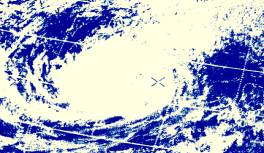 Fig. 16. Scanned Satellite Photo of SENING |
Typhoon PEPENG (Parma) New Entry!
September 30-October 11, 2009
120 kph (PAGASA estimate at Cagayan)
492 deaths
PhP 27.195B damage
Core (Eye & Eyewall) Track: Calanasan Pt., Aparri and Claveria, Cagayan; Luzon Strait; Bangui and Pagudpud, Ilocos Norte; Calanasan and Kabugao, Apayao; thru Alcala and Twin Peaks, Cagayan; off Divilican Bay and Eastern coast of Cagayan; Thumb Peak, Maconacon, Tumauini and thru Quirino, Isabela; Bontoc, Mountain Province; Sta.Lucia and Sta.Cruz, La Union; the mouth of Lingayen Gulf then out to South China Sea.
Days after Tropical Storm ONDOY (Ketsana) soaked Central Luzon and Metro Manila, PEPENG was a growing tropical storm at Philippine Sea moving towards Bicol and Eastern Luzon. Two days after its birth, it rapidly intensified to a supertyphoon, but its strength was short-lived when it entered the unusually dry air over eastern Bicol. By October 3, PEPENG decelerated to a regular-strength typhoon still moving northwest to Northern Luzon. Around 2PM of October 3 PEPENG made landfall at Calanasan Pt., Cagayan lashing the coastline with storm surges and rain was relentless all over Cagayan Valley and the Cordilleras. (see figures 17 & 18).
At that same time a powerful Typhoon named MELOR was cruising about a thousand miles to the east of Batanes, moving towards the sea south of Japan. As PEPENG exited the northwestern part of Cagayan, an interaction between the two typhoons called the Fujiwhara Effect occurred, thus stalling PEPENG at the Luzon Strait, west of the Babuyan Islands. Also, one contributing factor for PEPENG to slow down was due to the fact that, it had entered an area of weak steering environment. Thick storm clouds of PEPENG sent rain over triggering floods over Cagayan Valley as the Cagayan River overflowed. For three days PEPENG swirled and stalled at sea as MELOR lingered before moving away northeast. Then PEPENG moved southeast making landfall over Bangui, Ilocos Norte and again crossed Cagayan Valley then out to the Philippine Sea.
By October 7 PEPENG made a turnaround to the southwest making a third landfall at Thumb Peak in Isabela. By that time the continuous rains already saturated Cagayan Valley, Sierra Madre and the Cordilleras for 5 days triggering dozens of landslides isolating mountainous and remote towns and villages. PEPENG was hovering over the Mountain Province in the morning of October 8. Rains never ceased and dams all over Northern Luzon were in danger of breaching over. So authorities quickly raised the alarm that the dams will be opened to spill over excess water. For another 24 hours the rains continued. Baguio City was flooded and landslides all over Benguet, Mountain Province, Ifugao and Abra buried dozens of people inside their dwellings. All the rainwater and dam spills started thundering down to Pangasinan and caught fleeing people in their heels. Live aerial video footages showed horrifying scenes of brown muddy water swallowing entire towns and its people while a large shopping mall in Rosales, Pangasinan was engulfed in floodwaters with hundreds of shoppers trapped on its rooftop. At Baguio, the famous Burnham Park Lagoon overflowed and flooded adjacent areas. Burnham's fancy rowboats were then used to rescue trapped people all over central Baguio.
Killer landslides and widespread floods devastated the Cordilleras, Cagayan Valley, Pangasinan and the Ilocos Region when PEPENG finally left Luzon after ten days of incessant rains. Stories of drama and sorrow filled television and radio news on harrowing escape of victims thru heroic deaths of rescue groups and volunteers. PEPENG's effects all over Northern and Central Luzon were massively destructive and also deadly making it the country's most costly typhoon.
 Fig. 17. Track of PEPENG . |
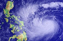 Fig. 18. Satellite Photo of PEPENG |
Super Typhoon LOLENG (Babs)
October 15-24, 1998
250 kph
303 deaths
PhP 6.787B damage
Core (Eye & Eyewall) Track: Virac, Catanduanes; Lanuy and Quinalasag Camarines Sur and Camarines Norte coastline; Polillio Islands; Dinangalan, Aurora; Gabaldon and Palayan City, Nueva Ecija; Urdaneta, Dagupan City, Alaminos and Bani, Pangasinan.
Typhoon LOLENG was a roaring howler by late Oct. 19 at the Philippine Sea heading for Bicol Region. Shortly after midnight of Oct. 20 LOLENG was in full fury of a Super Typhoon heading for Bicol, sending its strong winds and rain already at Eastern and Northern Samar (see figures 19 & 20).
At about early evening of October 21, LOLENG came ashore and hit directly Catanduanes with Virac taking full force of gusts up to 259 kph. After Catanduanes, it lashed the seacoast and mountains of Camarines provinces particularly Caramoan Peninsula with it's, then, weakening eye just skirting along the coastline of Daet, Camarines Norte. Damage was intense in the Bicol Region due to the fact that the storm just moved at a slow pace of around 11-15 kph during its passage. With this, high winds and heavy rains continued for 48 hours at the specified area, flooding the Bicol River Basin (from October 21 until the early morning hours of the 23rd).
By the early morning of the 22nd, it crossed Lamon Bay spawning surges along the coasts of Quezon Province. Polillio Island was also ravaged as the storm headed west-northwest for the whole day with winds and rain unceasingly devastating everything in its path. At dawn LOLENG came ashore at Baler and then to the heart of Nueva Ecija through Pangasinan destroying more of dwellings, buildings and agricultural lands. By early evening of that day, LOLENG slightly weakened as it exited the Lingayen Gulf and out to the South China Sea.
Areas already devastated by Super Typhoon ILIANG (Zeb) two days earlier were also affected adding more to the toll of death and devastation.
 Fig. 19. Track of LOLENG . |
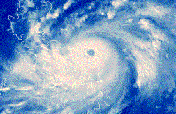 Fig. 20. Satellite Photo of LOLENG |
Typhoon AMY
December 6-19, 1951
240 kph
991 deaths
PhP 0.7B damage
Core (Eye & Eyewall) Track: Mercedes and Guiuan, Eastern Samar; Abuyog and Mac Arthur, Leyte; Cebu City and Toledo City in Cebu; San Carlos City, Murcia and Bago City in Negros Occidental; Southern tip of Guimaras, San Joaquin, Iloilo; Anini-y, Antique; Cuyo Islands and Northern Palawan.
Before the local weather bureau had Filipino names for typhoons, AMY became one of the most destructive typhoons of the country lashing all islands in the Visayas. (see figure 21).
AMY made landfall near Guiuan in Eastern Samar early afternoon of December 9. The typhoon then crossed Leyte Gulf and bore down forests and towns of Leyte sending large floods and landslides. By midnight and the early morning of December 10, AMY plummeled Cebu City and its outskirts destroying Cebu harbor and ships on dock. Houses and buildings were almost totally destroyed. It ravaged further the forests and towns of Northern Negros Occidental.
At about 7 AM, a storm surge slammed the entire Northwestern coastline of Negros Occidental from Bago up to Saravia with Bacolod City as the hardest hit. Houses and buildings that were destroyed by the winds were washed out by the storm surge relocating them more than a kilometer away from their foundations.
"The winds ripped-off roofs and tops of coconut trees. It seemed that those large tree branches and galvanized iron sheets targeted fleeing people killing them outright. Most of those killed were children floods and the raging sea swept houses away to the next barangay", described by witnesses at Bacolod City.
Floods remained for days at Bacolod and Iloilo as AMY fell more forests and houses in Anini-y, Antique. The typhoon still dumped more rains and threw its tempest by early morning of December 11 at Northern Palawan. As the typhoon exited it slowed down and remained quasi-stationary for 2 days at the Spratly Islands dumping heavy rains at Northern Palawan. It then recurved creating a loop and finally exited to South China Sea.

Fig. 21. Track of Typhoon AMY
Typhoon UNDANG (Agnes)
November 3-6, 1984
230 kph
895 deaths
PhP 1.9B damage
Core (Eye & Eyewall) Track: Llorente, Eastern Samar and Talalora, Samar; Babatngon, N. Leyte incl. Naval in Biliran Is., coast of Esperanza, Masbate; Gigante Islands in Carles, Northern Iloilo; coastline of Roxas City, Sapi-an Bay and the rest of Capiz seacoast; Batan and the rest of Aklan; Sebaste, Northern Antique; Coron and Culion Islands of the Calamian Group.
A little over a month after Nitang ravaged the Visayas and Northern Mindanao, UNDANG entered the country as a very strong typhoon and reached almost super typhoon status ravaging Southern parts of Samar Island by early morning of November 5. It slightly weakened but still slammed Tacloban City with a full fury of devastating winds wrecking buildings and houses and snapping trees and electric posts. It regained strength as she crossed the Visayan Sea by the middle of the day heading full-force to the islands off Carles in Iloilo Province (see figures 22 & 23).
It struck Carles and towns in Northern Iloilo at about noontime and plummeled its howling winds and powerful waves that battered the Northern coast of Capiz, wiping out coastal barangays, twisting metal trusses and galvanized iron roofs flattening houses in other coastal municipalities up to the capital, Roxas City. The enormous Panay (pronounced as Pan - ay) River overflowed, transforming half of Capiz into a sea of raging waters filled with debris from trees, houses, fishponds and corpses with dead animals. Survivors who were swept by the floods found themselves clinging to floating debris and bloated corpses at sea. Ships and other seacrafts docked at Roxas Citys Culasi Port were destroyed and sunk while the port itself sustained insurmountable damage.
Devastation continued as rains filled the rivers, drowning people and communities of the rest of Capiz, Aklan, Central Iloilo Province and Northern Antique. By early evening of that day it left Panay Island and devastated the Calamian Group of Islands in Palawan before exiting by dawn of November 6 at the South China Sea.
 Fig. 22. Track of UNDANG. |
 Fig. 23. Scanned Satellite Photo of UNDANG |
Note: The places indicated in the core track are the areas directly passed over by the center of a tropical storm or the "eye" of the typhoon and its eyewall - a heavy convective mass of clouds surrounding the center/eye of a tropical cyclone. It is here where the strongest winds and heaviest rainfall can be observed.
Summary written by Dominic Alojado, MD. with additional information by David Michael V. Padua of Typhoon2000.com.
Revised/New Edition: July 29, 2010.
Copyright © 2010 Typhoon2000.com All Rights Reserved.