click to return to main page
Philippine Tropical Cyclones: 2010 Season


Click here to zoom Florita's full MTSAT-2 Satellite enhanced image!06. Tropical Depression FLORITA (Lionrock/07W)
August 27 - 28
Max Sustained Winds: 55 kph (30 kts)
Min Central Pressure: 1000 mb
[Storm Log|Tracks: PAGASA/JTWC/JMA|WikiSummary]
[JAXA/EORC's TRMM, Aqua, Midori-II Observation Page]


Click here to view Glenda's full MTSAT-2 Satellite enhanced image!07. Typhoon GLENDA (Kompasu/08W)
August 29 - 31
Max Sustained Winds: 175 kph (95 kts)
Min Central Pressure: 952 mb
[Storm Log|Tracks: PAGASA/JTWC/JMA|WikiSummary|NASA EO Page]
[JAXA/EORC's TRMM, Aqua, Midori-II Observation Page]


Click here to view Henry's full MTSAT-2 enhanced image!08. Tropical Storm HENRY (Malou/10W)
September 02 - 04
Max Sustained Winds: 65 kph (35 kts)
Min Central Pressure: 996 mb
[Storm Log|Tracks: PAGASA/JTWC/JMA|WikiSummary]
[NASA EO Page|JAXA/EORC's TRMM, Aqua, Midori-II Observation Page]


Click here to view Inday's full MTSAT-2 Satellite enhanced image!09. Typhoon INDAY (Fanapi/12W)
September 14 - 19
Max Sustained Winds: 195 kph (105 kts)
Min Central Pressure: 944 mb
[Storm Log|Tracks: PAGASA/JTWC/JMA|WikiSummary|NASA EO Page]
[JAXA/EORC's TRMM, Aqua, Midori-II Observation Page]


Click here to view Juan's full MTSAT-2 Satellite enhanced image!10. Super Typhoon JUAN (Megi/15W) Deadly/Disastrous
October 15 - 20
Max Sustained Winds (Recon Data): 305 kph (165 kts)
Min Central Pressure (JMA): 885 mb
[Storm Log|Tracks: PAGASA/JTWC/JMA|WikiSummary|More SatPic]
[Satellite Flash Movie: Oct 17-20, 2010 (1.97 MB)|NASA EO Page]
[JAXA/EORC's TRMM, Aqua, Midori-II Observation Page|T2K Hourly Updates]


Click here to view Katring's full MTSAT-2 Satellite enhanced image!11. Typhoon KATRING (Chaba/16W)
October 23 - 28
Max Sustained Winds: 215 kph (115 kts)
Min Central Pressure: 937 mb
[Storm Log|Tracks: PAGASA/JTWC/JMA|WikiSummary|NASA EO Page]
[JAXA/EORC's TRMM, Aqua, Midori-II Observation Page]


Return to Summary | Page 1 [2] Back... | Top

- Deadly/Disastrous

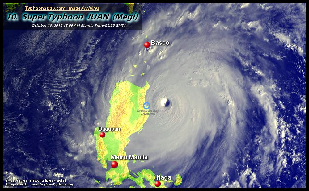
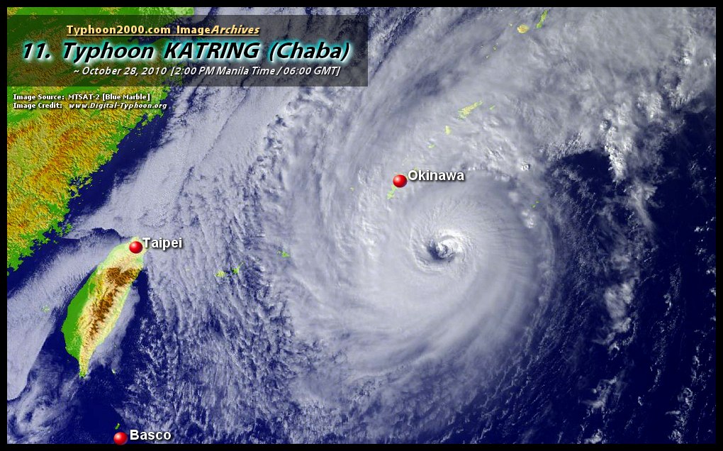
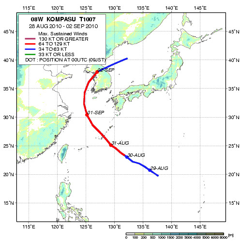
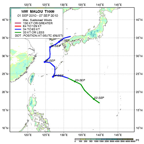
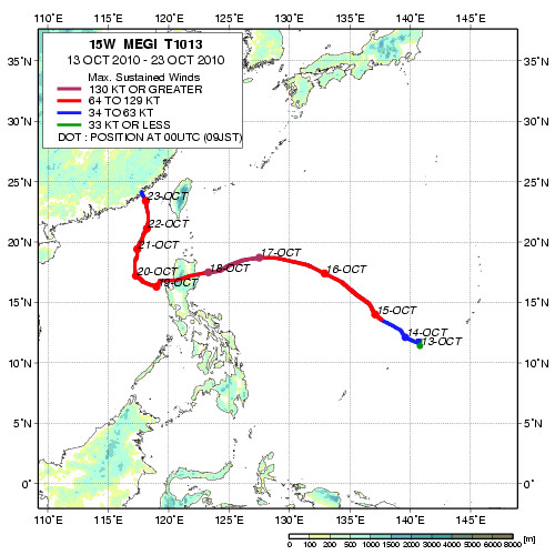
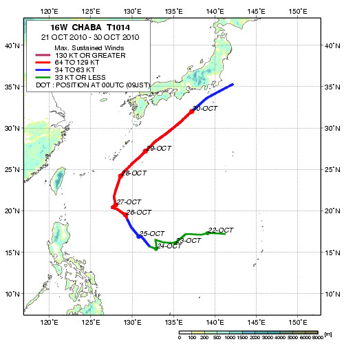
:: This summary is based on Tropical Cyclones within the Philippine Area of Responsibility (PAR) ::

[Note: Local names issued by PAGASA; In parenthesis are Int'l. names given by UN Typhoon Committee and
followed by JTWC's designated TC Number / Maximum Sustained Winds based on 1-Min. Average (JTWC)
except as indicated (*): based on 10-Min. Average (PAGASA) / Minimum Central Pressure by PAGASA or
NRL Monterey
/ JTWC Tracks by Hawaii Solar Astronomy (HSA) and JAXA-NASA / JMA Tracks by Japan
Meteorological Agency's Tokyo-Typhoon Center / Storm's WikiSummary courtesy of Wikipedia NW
Pacific Typhoon Season / Thumbnail and links images courtesy of NASA Earth Observatory,
NOAA OSEI, & Digital-Typhoon.org / Damage reports courtesy of Disaster
Risk Reduction Management Council (DRRMC)]

 click here for free download!


This page was last updated:
Tue, March 29, 2010 @ 09:02 GMT